My PCT journey was so much more than the numbers, but as an analytical person, I like the numbers too. They are another lens I can use to process the experience.
A graph provides a succinct visualization of a very complex 2,655 mile journey. It certainly doesn’t capture everything, but it gives my brain a visual model, knowing that all the complexities, personal narratives, and memories lie inside.
Mileage
| Total PCT miles | 2655.2 |
| Actual miles hiked (incl. alternate routes, detours, shortcuts, etc.) | 2653.8 |
| Miles skipped | 0 |
According to FarOut, hiking on the PCT from Mexico to Canada is 2655.2 miles, though it’s virtually impossible to hike solely on the PCT the entire way. Every year there are trail closures due to fires or damaged trail. On my journey, I opted to take alternate routes around closures in order to keep a continuous footpath.
I also opted to take alternate trails/roads when it was a more scenic, or shorter, option.
Sometimes the alternate routes were shorter, sometimes they were longer. Despite numerous reroutes, I was surprised to learn that the overall difference between PCT miles and my actual miles hiked was only 1.4 miles (2655.2 vs. 2653.8).
Days and Dates
| Start date | April 9 |
| End date | September 16 |
| Fill-in section | September 23-25 |
| Total # days | 164 |
According to halwayanywhere.com, for the past five years, the average number of days it took for thru-hikers to complete a thru-hike was between 148 and 162. At 164 days, or about 5.5 months, I was slightly above the average time.
There was one 80-mile section in Oregon that I had to temporarily skip in August. I could not find a safe way around the Middle Fork fire in the Diamond Peak Wilderness. However, a week after reaching the northern terminus, I returned to this section to fill in the gap. The 164 days include the extra 3 days from September 23-25 to complete this section, but does not include the week off in between.
The -eros
| # of zeros | 19 |
| # of nearos (<10 miles) | 23 |
| # of full hiking days | 145 |
| Total | 164 |

A zero is a rest day, a day of zero miles. A nearo (near zero) is a subjective term; there is not a set definition as to what counts as a nearo. I’m defining it here as any day less than 10 miles.
Daily Mileage Averages
| Including zeros | 16.2 |
| Not including zeros | 18.3 |
| Not including nearos (<10 mi) | 21.6 |

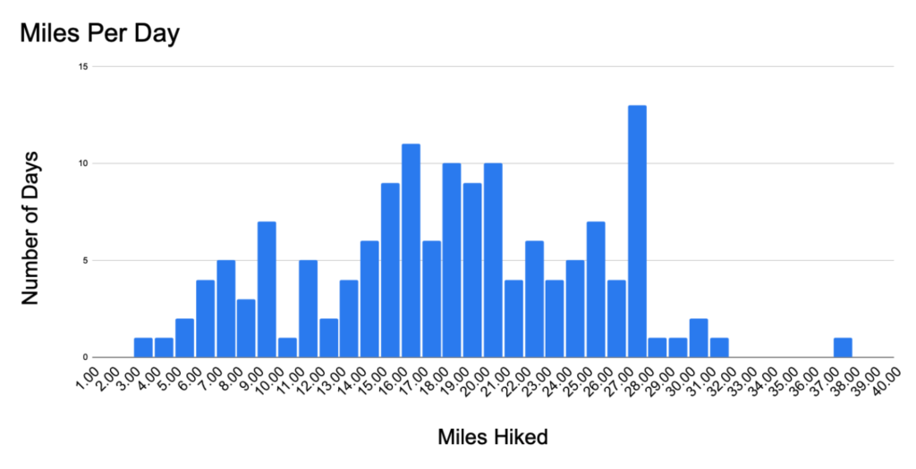
The trendline shows that my daily mileage increasing over time.
| Longest day | 37.0 mi |
| Shortest day | 3.1 mi |

My most common length of day was 27 miles, though I rarely had days longer than that.
By Section
| Section | Miles | # days | Daily Average (incl. zeros) |
|---|---|---|---|
| Desert | 566 | 52 | 10.9 |
| Sierra | 527 | 33 | 16.0 |
| NorCal | 626 | 33 | 19.0 |
| Oregon | 492 | 24 | 20.5 |
| Washington | 505 | 22 | 23.0 |
My daily mileage average increased with each section.
Though the desert was a relatively easy section, I started slow to build strength and avoid injury. In the Sierra, it was difficult to hike big-mile days due to snowy conditions, water crossings, and the mountain passes. Oregon was probably the easiest section and where I began to hike big-mile days. I personally found Washington to be the hardest section, but I had built my strength and endurance, and was determined to finish by mid-September. Despite the challenges, I was able to hike my fastest in Washington.
Sleeping Location
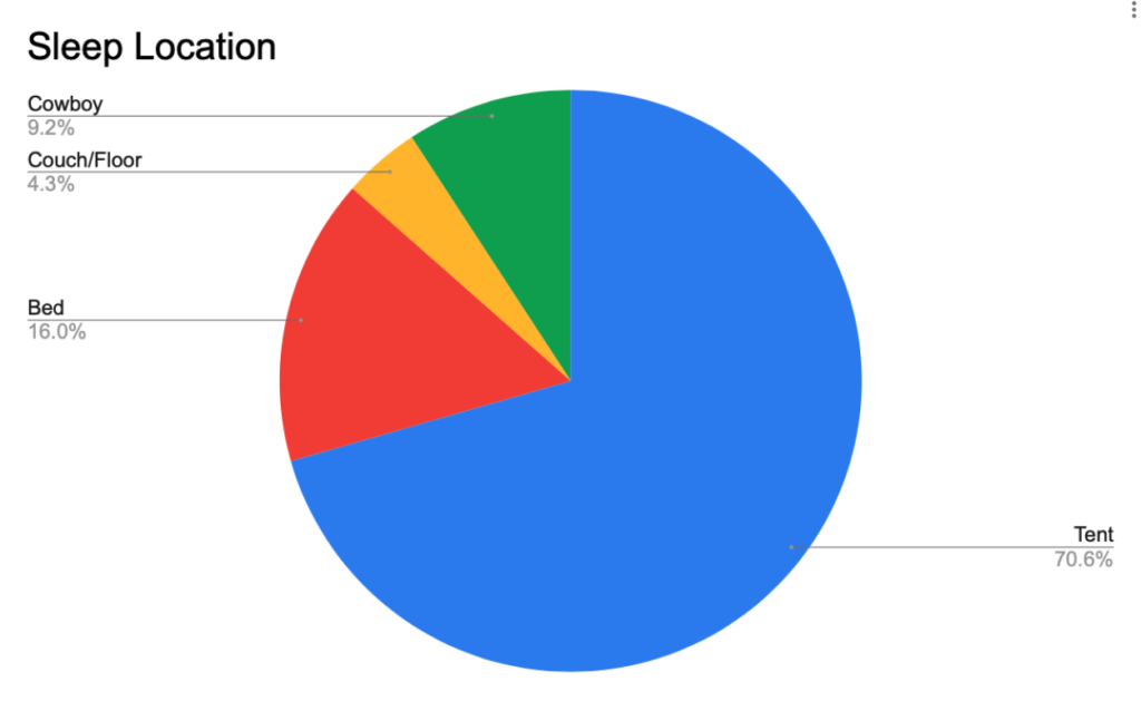
| Nights in a tent | 115 |
| Nights cowboy camped | 15 |
| Nights in a bed | 27 |
| Nights on a couch or floor | 7 |

The majority of my nights were spent outdoors, either in my tent or cowboy camping (sleeping under the stars). When in town my tramily and I would generally split a hotel room or AirBnB.
Resupplies
| Total # of resupplies | 37 |
| Average # days between resupply | 4.4 |
| Average # miles between resupply | 71.8 |
| Longest | Shortest | |
|---|---|---|
| Water Carry | 22.2 mi | <1 mi |
| Food Carry | 7.5 days | 1.5 days |
| Distance between resupplies | 148.3 mi | 21.6 mi |
I thought my longest water carry would be in the desert, but it was actually in the Mount Tielson Wilderness in Oregon. If it weren’t for the kindness of trail angels volunteering to maintain water caches, some of my water carries would have been much, much longer.
My shortest food resupply was the 1.5 days between Cajon Pass and the town of Wrightwood. Cajon Pass is home to the famous on-trail McDonald’s, where I did the “McDonald’s Challenge,” i.e. resupplying only from McDonald’s food.
My longest food carry in days was in the Sierra, between Kennedy Meadows South and Bishop via Kearsarge Pass (7.5 days/111.3 mi). This section included the ascent of Mt Whitney.
In terms of miles, however, my longest food carry was in Washington, between Cascade Locks and White Pass (6 days/148.3 miles).
Wildlife Sightings
| Bears | 3 |
| Coyotes | 5 |
| Rattlesnakes | 8 |
| Trail horses | 21 |
I thought I would see more bears on the PCT. Of the 3 black bears I saw, 2 were in the Sierra and 1 was in Washington.
I saw 8 rattlesnakes, but some of my friends saw many more. It’s a little disconcerting knowing that I probably walked by dozens of rattlesnakes without noticing them.
The PCT generally has moderate grading in order to be walkable by pack animals. Despite the trail being built to be accessible by horses, I was surprised to only see 21 horses in 2655 miles, and half of them were all in one group.
Miscellaneous
| Total elevation gain | 489,000 ft |
| Weight lost | 26.5 lbs |
| # photos taken | 2,139 |
This article originally appeared on the Trek, which you can read here.


Hi Kirby
I’ve been following your posts since before you started your train trip across country. I’m impressed by your stats. I’m a math advocate so I appreciate your dedication to basic facts. Be well 🙏
Thank you much! I really appreciate your readership and words of encouragement along the way!
I look forward to your book about your adventures! Or should I say book series? You are a very good writer even when it is just numbers!
Thanks so much!
Hi Kirby, Thank you for sharing your journey! I enjoyed living vicariously through you as your trek took you into some incredible areas. Numbers are satisfying in that they are a method to measure/validate although there is so much more to your story. I am truly in awe of your accomplishment! Enjoy some well earned downtime 🙂
Corinne
Thanks Corinne!!
Hi Kirby
Really enjoying reading your blog and posts here and elsewhere as I plan to attempt the PCT next year. I have a fair bit of experience in Europe but none in the US so it is very helpful. On your costs post I noticed you started with a tent similar to one I have but didn’t like it and swapped it out halfway. Would you mind commenting on what irritated you with your first shelter, what you moved to, and whether that was better?
Thanks
all best
jack
Thanks Jack! You can read my review of the ProTrail here: https://www.greenbelly.co/pages/tarptent-protrail-review, but in short, the lack of headspace started to get to me. It probably wouldn’t have bothered me on a shorter hike, but on a multi-month hike like the PCT, I really wanted to be comfortable. I ended up with the Durston XMid 1, which I was pretty happy with. It was heavier, but with a double wall to reduce condensation and more headspace, I decided it was worth the weight penalty. The Durston was very popular on the PCT this year. I would estimate probably 1 in 4 hikers had the XMid 1 or 2.
Best of luck on your PCT prep!!!
I think this web site holds some very good information for everyone :D. “As ill-luck would have it.” by Miguel de Cervantes.